| NWS Weather Forecast -
Outlook Overnight & Tuesday |
Overnight

Chance Rain Showers
Lo 68°F
|
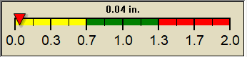
NWS forecast: A chance of rain showers. Mostly cloudy, with a low around 68. East southeast wind 6 to 12 mph. Chance of precipitation is 70%. New rainfall amounts between a tenth and quarter of an inch possible.
|
Tuesday

Chance Rain Showers
Hi 80°F
|
NWS forecast: A chance of rain showers. Mostly cloudy, with a high near 80. East wind 6 to 14 mph, with gusts as high as 18 mph. Chance of precipitation is 70%. New rainfall amounts between a quarter and half of an inch possible.
|
|
| NWS Short Term Weather Forecast |
|
Tuesday
Night

Chance Rain Showers
|
Wednesday

Scattered Rain Showers
|
Wednesday
Night

Scattered Rain Showers
|
Thursday
Scattered Rain Showers
|
Thursday
Night

Scattered Rain Showers
|
Friday

Scattered Rain Showers
|
Friday
Night
Scattered Rain Showers
|
|
Lo 68°F |
Hi 80°F |
Lo 67°F |
Hi 80°F |
Lo 68°F |
Hi 80°F |
Lo 67°F |
|
ajax-dashboard6.php - Version 6.95h - 20-Feb-2023 - Script by: Scott of BurnsvilleWeatherLIVE.com
Now supported by Saratoga-weather.org Download
|